The Construction of urban highways in city centers, a destructive and obsolete practice
In contemporary policies of urban planning, rare are the cities that still pierce their historic city centers to create urban highways, for two main reasons:
1 – The municipalities of most important cities have realized, since the 1970s, that the construction of urban highways within city centres resolve traffic problems on the short term only and feed a vicious cycle : indeed, every expansion of the express highway system in the centers create an incentive for more usage of private vehicules. It has been observed, in European and Mediterranean cities, that this incentive to use the car leads to the quick saturation of the new infrastructures, which are extremely expensive and destructive for the life of the city and its neighborhoods. This has led, since the 1970’s, to a strong repositioning of transportation planning and a total inversion of transport policies:
-Increasing the role, space and usage of public transport (for example, a simple network of busses on dedicated bus lanes would be adapted to the case of Beirut).
– Discouraging car usage in central neighborhoods. Thus, the city of Paris is today shutting down the express highways along the Seine River, to give the riverside back to pedestrians and soft motilities. The city of London has established a tax for private vehicles that enter the city centre and the city of Athens forbids everyday one in two cars from circulating in the city centre. Many cities of the United States (such as Boston), of Canada or even South Korea (Seoul) even go further: They are demolishing the urban highways that were built in the 1970’s and are reorganizing them to heal the neighborhoods damaged by their construction… inducing enormous costs, 40 years after their initial construction.
2 – A city that destroys everyday an even larger part of its living environment, of its architectural and landscape heritage, is a city that loses its historical identity, the character and charm of its neighborhoods and the quality of its public spaces. All Arab cities around the Mediterranean Sea have understood this and have managed to preserve their historical heritage. The extremely liberal contact of Lebanon however makes it very difficult to adopt the same kind of policies. However, much of the heritage that is endangered by the project has an enormous advantage: It has been expropriated and is already the property of the public sector, which can, in application of the law of 8/12/2006, change the original reason for the expropriations for another project, of public interest.
The Fouad Boutros highway will not necessarily resolve initial problems and will even create new ones
Indeed, even if this new urban highways will create a new entrance from the north into the Achrafieh area by completing the grid which was imagined more than 50 years ago (though the understanding of cities as known many revolutions since these times), it will however cause :
– Transit traffic, which does not concern the neighborhoods it will cross, but will affect them deeply by causing many disturbances, whereas this same traffic today takes the Beirut River express way (Emile Lahoud avenue) and the Corniche el-Nahr avenue(Pierre Gemayel avenue).
– A funnel effect, which will direct an additional, very large number of vehicles coming from Charles Helou, onto the Alfred Naccache avenue and the Mar Mitr neighborhoods, which are already over-saturated today because of the parking entrances of ABC and Spinney’s centre, because of the Hotel Dieu entrance and because of the many necessary U-turns and crossroads.
– The Fouad Boutros highway project is supposed to be a continuity of the Alfred Naccache avenue, which today links together, at the local level, many centers of economic activities, services, public equipments. One major flaw of the Fouad Boutros highway is that it will cause a major imbalance of road functions, by superposing very important transit/regional flows on these local car motilities.
– In order the sustain these traffic changes, the Alfred Naccache Avenue will need to change status. It should be widened to hold 2 x 4 lanes to adapt to its new transit status while preserving its status as a local connector within the city-centre. 2 transit lanes and 2 local distribution lanes, on each side. However, the width of the Alfred Naccache Avenue and the proximity of adjacent buildings make it impossible to widen and increase its capacity.
The justification of the Fouad Boutros highway pretends to be mainly based on the orientations and recomandations of the “Ecochard Plan” from 1952. However this plan has been distorted in the later “Schéma Directeur du Grand Beyrouth” of 1964, which was disapproved by Michel Ecochard himself! Furthermore, the Plan was again changed in 1993-1994. As the original “Ecochard Plan” has been so much altered, it is irrelevant and inappropriate to use it as a justification for infrastructures built 60 years after it was first drawn! A completely new and detailed understanding of traffic in Beirut needs to be built, also taking into account the social, economic, cultural and environmental dimensions which were omitted in the original plan of 1952.
———————————————————————————————————–
An unnecessary, redundant and counter-productive project
As said earlier, the “Hekmeh-Turk” axis (Fouad Boutros highway) is supposed to be completing the “grid” of urban highways drawn in the Ecochard master plan. It is supposed to create a new connection between Achrafieh and, mainly, the eastern suburbs, through the Charles Helou avenue.
However, the need for such a connection is highly questionable.
Indeed, entering Achrafieh from the East already happens through 5 primary roads:
– Charles Malek avenue
– Independance avenue
– Alfred Naccache avenue via Pierre Gemayle avenue
– Georges Haddad avenue via Charles Helou avenue
– Armenia street
A number of secondary streets give also access to Achrafieh, such as the Sioufi slope (tal3et el-Sioufi), Badaoui street or Jean Jalkh street.
Existing Achrafieh towards the East happens through 5 primary roads:
– Charles Malek avenue
– Independance avenue
– Alfred Naccache avenue
– Charles Helou avenue
– Armenia street
Also, a number of secondary streets allow to exit Achrafieh, especially the numerous side streets that connect Armenia street directly to Charles Helou avenue.
There are already 6 urban highways and many secondary street that penetrate and surround an area that is roughly 1km x 2.5km. Every neighborhood of the area is already well connected to at least one of those urban highways :
– People in Mar Mikhayel and Gemmayzeh use Charles Helou avenue and Armenia street.
– People in Tabaris, Furn el-Hayek and Geitawi use Charles Malek avenue.
– People in Fassouh, Abdel-Wahab and Monot-Huvelin use Independance avenue.
– People in Sioufi and Nasra use Alfred Naccache avenue and Pierre Gemayel avenue.
Adding one more urban highway is clearly unecessary. Especially if we turn our attention on a potential itinerary, from Emile Lahoud avenue to Charles Malek avenue. As we will see later in the “traffic alternative” part, if the connection between those two avenues is made efficient, this itinerary could play the exact same role as the Fouad Boutros highway, rendering it useless and redundant.
Furthermore, it is now a known fact that urban highways attract more cars within the city. They are also known for displacing traffic congestion from one point to another. They do resolve traffic problems on one end, only to transport it one the other end. Something that will be particularly problematic in this case. The Fouad Boutros highway will take the traffic congestion that does indeed happen on Armenia street and Charles Helou avenue, and will displace it on Charles Malek avenue and Alfred Naccache avenue, which are already congested and cannot be widened. On the other hand, the project does not, in any way, resolve the points of traffic congestion that already exist on Charles Malek and Alfred Naccache and will even contribute to worsen them by directing even more traffic onto them.
It is time to debunk the long-held belief that roads are necessarily a solution to traffic. Roads generate traffic as well. The Fouad Boutros bridge is meant to facilitate through traffic but in effect, it is going to create more congestion on Alfred Naccache Street and on Charles Helou bridge. As has been argued repeatedly by transportation engineers, the Alfred Naccache Street is not wide enough to accommodate the flow. It is also a surface road with too many large commercial outlets that add to the traffic – Hashim Sarkis, architect, urban designer
———————————————————————————————————–
A project very detrimental to local car traffic and itineraries
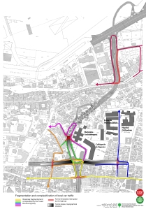
As seen earlier, the highway and its infrastructures will cut and fragment local car itineraries. As a result, several of the local itineraries will become much more complicated, much longer, and will be a cause of traffic congestion. This will be especially the case of the entrances and exists of the Hekmeh neighborhood whose accessibility will suffer. Also very worrying is the fact that the Mar Mitr street will be cut and that going from the east to the west side of it will necessitate a detour on Charles Malek avenue.
———————————————————————————————————–
A badly organized and flawed project
Another very worrying point of the Fouad Boutros highway is its connection with the Charles Helou avenue. An extremely ridiculous situation, since this spot is the most strategic of the whole highway, the one that is supposed to ensure efficient circulation between Achrafieh and the eastern suburbs. However, upon close inspection of the segment of the highway that is north of Armenia street, its defect become obvious.
A very large number of itineraries go through this northern part of the Fouad Boutros highway, between Achrafieh and Armenia street, between Charles Helou avenue and Armenia street, between Achrafieh and Charles Helou avenue. This large number of exchanges, on a single strip and interchange, will be a cause of traffic congestion. Especially since this interchange is very badly designed and will cause the crossing of several of these itineraries. Traffic flow conflicts will emerge and will certainly cause traffic jams.
———————————————————————————————————–
Bringing trucks into achrafieh?
An unclear element of the project is the connection of the Fouad Boutros highway to the Port. The current plan shows, at the extremity of the interchange, a small connection with the streets of the Port. Which means that trucks coming in and out of the Port could transit through Achrafieh, a further nuisance that will be added to the general traffic congestion. Though the Municipality and CDR ensure that trucks will not be allowed to go onto the Fouad Boutros highway, into Achrafieh, the fact that a connection IS drawn with the port leaves the question open. If so, it would be a ridiculous decision, as a connection between the Port and Damascus road and Syria already exists through the Emile Lahoud avenue.
———————————————————————————————————–
For the full traffic impact report (in french) click here
For the summarized study conducted by the Coalition (in arabic) click here
For the study on the impact of the highway on the parcelles north of Armenia street, click here


